⛳ Pukehau is situated in or near the warm temperate dry forest biome.
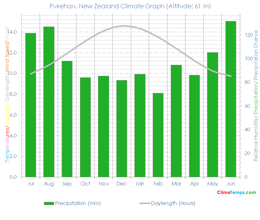
☔ Total annual precipitation averages 1172.2 mm (46.1 inches) which is equivalent to 1172.2 Litres/m² (28.75 Gallons/ft²).
Simply paste the following HTML code into your webpage. Please include a link back to this website. There is one in the following code already. Edit the width attribute to change the size of the graph if needed:
✨ The longest day of the year is 14:28 long on the 21 of December and the shortest day is 9:32 long on the 22 of June.
🐇Were you to burrow down through the centre of the Earth from Pukehau you would pop up nearest to the climate station at Gibraltar, Gibraltar where you would find a Mediterranean climate (Subtropical dry forest biome).
🌍Pukehau, New Zealand is at 36°12'S, 174°15'E, 61 m (200 ft). Check the location on the map.
| Climate Variable | Jul | Aug | Sep | Oct | Nov | Dec | Jan | Feb | Mar | Apr | May | Jun | Annual | ||
|---|---|---|---|---|---|---|---|---|---|---|---|---|---|---|---|
| Average Precipitation mm (in) | 121 (5) | 127 (5) | 98 (4) | 84 (3) | 85 (3) | 82 (3) | 87 (3) | 71 (3) | 95 (4) | 86 (3) | 105 (4) | 132 (5) | 1172 (46) | ||
| Average Daylight Hours/ Day | 9h 57' | 10h 48' | 11h 56' | 13h 07' | 14h 06' | 14h 34' | 14h 19' | 13h 30' | 12h 24' | 11h 13' | 10h 14' | 9h 44' | 12h 00' | ||
| Sun altitude at solar noon on the 21st day (°). | 33.3 | 41.6 | 53 | 64.2 | 73.4 | 77.2 | 73.6 | 64.3 | 53.6 | 42.1 | 33.7 | 30.4 | 53.4 |
Please take a moment to share a climate graph or simply the address:
Thank You, so much! ❤️